Martian ‘Rocky Road’: ESA’s Mars Express Reveals Crater Soaked in History
Imagine a crater on Mars, layered with volcanic rock, carved by ancient rivers, and sculpted by ice over billions of years. That's Deuteronilus Cavus, a 120-km wide depression recently captured in stunning detail by the European Space Agency's Mars Express. This isn't just a hole in the ground; it's a living textbook that showcases the dynamic geological processes that have shaped the Red Planet, offering a tantalizing glimpse into its complex past.

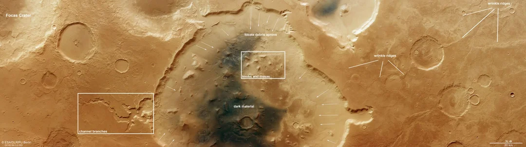
According to the ESA, Deuteronilus Cavus, situated between the rugged southern highlands and smoother northern lowlands, is a treasure trove of geological history. Its nearly circular shape suggests an origin from an asteroid impact around 4.1 to 3.7 billion years ago – a period when the solar system was bombarded by space rocks.
But the impact was just the beginning. Over eons, water, ice, and wind have dramatically reshaped the crater. Channels cutting through the crater rim hint at ancient rivers that once flowed across the Martian surface, or perhaps water draining from beneath, collapsing the ground above. The grooved surfaces suggest the presence of glaciers, where boulders frozen into the ice carved out trenches as they moved. These features paint a vivid picture of a Mars that was once much wetter and more dynamic than the arid world we see today.

The crater's interior is a chaotic mix of knobs, mesas, channels, and plains, described by ESA as resembling a "rocky road" cake. Stronger blocks of rock have resisted erosion, while darker deposits, likely volcanic ash, cover much of the surface. Brighter deposits contain clay minerals, indicating the presence of water that ponded here.
Adding another layer to the puzzle are the wrinkle ridges rippling across the smoother terrain, formed as lava flows cooled and contracted. This evidence of volcanic activity further emphasizes the diverse geological history of Deuteronilus Cavus.
The Mars Express mission, which has been observing Mars for over two decades, continues to provide invaluable insights into the Red Planet. The High Resolution Stereo Camera (HRSC) allows scientists to analyze Martian terrain with unprecedented detail. The images reveal details of the rim erosion, branching channels likely formed by groundwater seeping to the surface.
Deuteronilus Cavus is not just a formation; it's a testament to Mars' ever-evolving landscape. The interplay of asteroid impacts, water activity, glacial movement, and volcanic processes has created a unique and compelling geographical feature.
What secrets will future missions uncover within this Martian "rocky road"? Share your thoughts and theories in the comments below.