China’s Chang’e-6 Mission Unveils Lunar Far Side Secrets: High-Precision Mapping and AI-Powered Discoveries
China's Chang'e-6 mission continues to deliver groundbreaking insights into the lunar far side. Recent analyses, leveraging high-resolution imagery and AI-powered digital elevation models, are revealing unprecedented details about the landing site's terrain and geological history. These findings not only provide crucial context for the returned lunar soil samples but also challenge existing theories about the moon's formation and evolution.
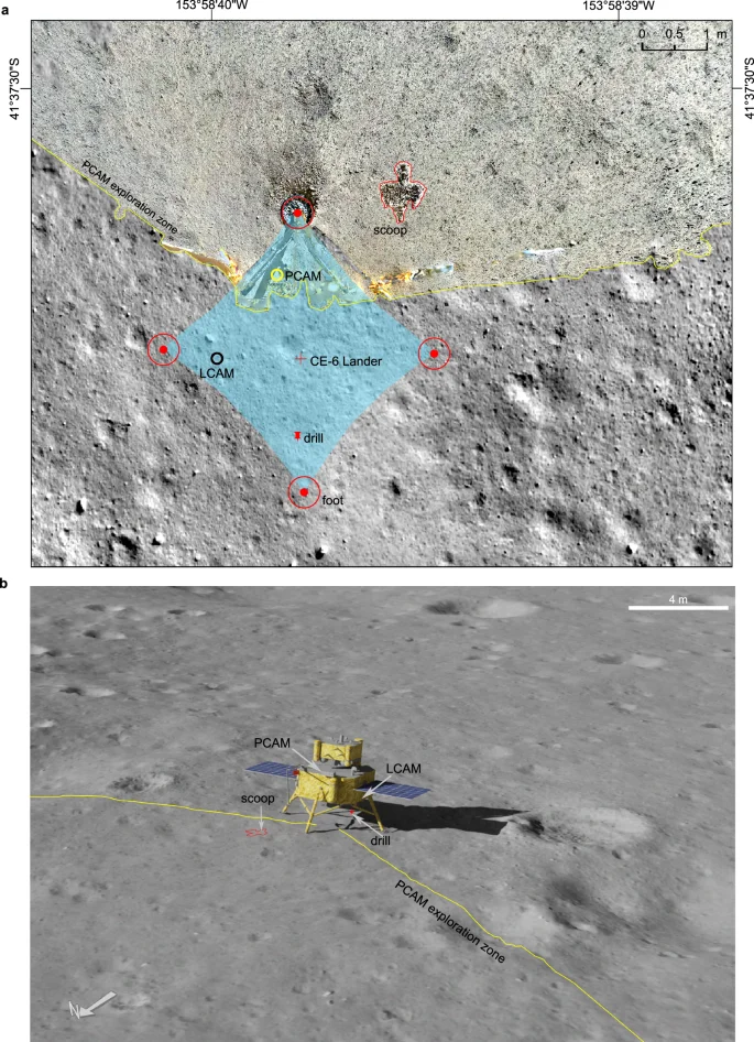
One key development is the creation of a high-precision terrain dataset of the Chang'e-6 landing area. Using images captured by the mission, Chinese researchers have constructed a detailed map identifying the exact landing site and revealing fine surface features like soil grain roughness, crater morphology, and regolith thickness. This dataset serves as an "ID card" for the lunar soil samples, essential for accurate laboratory analysis.

The research, published in Nature Communications, highlights that Chang'e-6 landed on the southwestern edge of Crater C1, a 51-meter diameter crater located in a region of lunar mare basalt. Compared to the landing areas of Chang'e-4 and Chang'e-5, the surface roughness, crater depth-to-diameter ratio, regolith thickness, and rock abundance at the Chang'e-6 site fall between the two, suggesting a surface exposure age that also lies in between.
Further analysis indicates that the landing zone is covered with impact ejecta. Calculations suggest the soil is a mix of local basalt from Crater C1 (30-35%) and exotic material from more distant craters. This detailed understanding of the site's geological composition is critical for interpreting the lab results of the returned samples.
In a separate but related development, an AI-powered method is providing new insights into the moon's ancient tectonic activity. A research team from the Aerospace Information Research Institute (AIR) of the Chinese Academy of Sciences has developed an innovative approach using a generative adversarial network (GAN) to create high-resolution digital elevation models (DEMs).

By combining high-resolution imagery from NASA's Lunar Reconnaissance Orbiter Camera (LROC) with lower-resolution DEM data, the team generated pixel-scale DEMs at an impressive two-meter resolution. This allows for detailed analysis of lobate scarps, small reverse fault landforms indicative of ancient tectonic activity.
The study, published in Icarus, focuses on 18 lobate scarps located approximately 300 km northwest of the Chang'e-6 landing site within the Apollo basin. The analysis suggests that these scarps were formed by intense horizontal pressures exceeding 400 megapascals within the last 80 million years, potentially caused by the moon slowly shrinking as it cooled. This conclusion supports the initially totally molten (ITM) model of lunar formation, challenging the traditional lunar magma ocean (LMO) model.
Adding to the geological portrait, new observation data has unveiled the micro-scale characteristics of the Chang'e-6 landing area. Researchers utilized high-precision in-situ exploration data to reconstruct a detailed terrain dataset. This allows for accurate determination of the geographical location of the landing site, in relation to the lunar samples and combined remote sensing data.

The precise location of the Chang’e-6 landing site was determined as (153.9776° W, 41.6251° S, -5273 m). Micro-scale topographic analysis identified and extracted craters and rocks, analyzing geological characteristics within millimeters, up to sub-kilometers. A comprehensive analysis with the landing areas of Change'e-4 and Change'e-5 was conducted to determine the surface exposure time of the Change’e-6 landing zone.
Furthermore, based on morphological features, the estimated lunar regolith thickness at the Chang’e-6 landing area is 3.4 to 8.5 meters. It's similar to that at the Chang’e-5 landing area, but shallower than at the Chang’e-4 landing area. The geological characteristics of the CE-6 landing area at the micro-scale, such as surface roughness, also all fall between those of the CE-4 and CE-5 landing areas.
These findings provide valuable context and supporting evidence that could benefit the interpretation of laboratory analysis results. These findings combined provide a comprehensive understanding of the landing site's geological composition and the potential origins of the returned samples. The local marre materials from crater C1 and foreign ejecta with Mg-rich materials may originate from crater Chaffee S.
The Chang'e-6 mission continues to push the boundaries of lunar science. By combining advanced imaging techniques, AI-powered analysis, and detailed geological studies, researchers are unlocking the secrets of the lunar far side and challenging existing paradigms about the moon's history. What new insights will the analysis of the returned lunar samples reveal? Share your thoughts in the comments below!