Operation Sindoor: Satellite Imagery Reveals Damage to Pakistani Airbases, Amidst Information War
Operation Sindoor, India’s response to recent terror attacks, has unfolded not only on the ground and in the air but also in the digital realm. While official statements and social media buzzed with claims and counter-claims, satellite imagery has emerged as a crucial tool for verifying the extent of the operation's impact. This is a break down of the information war and provides clarity amidst conflicting narratives.
Kawa Space, an Indian spacetech startup founded by Kris Nair, has played a significant role in providing credible satellite-based intelligence. Their high-resolution images, shared on social media and with defense-related websites, have offered visual proof of the damage inflicted on Pakistani targets. Nair's cryptic posts, hinting at major developments and showing images of potentially targeted sites, have fueled speculation and highlighted the growing importance of the private space sector in defense operations.
While both India and Pakistan engaged in an information war, claiming extensive damage inflicted on each other, an examination of satellite imagery reveals a more nuanced picture. According to reports, the damage was more contained than claimed, with India inflicting most of the verified damage on Pakistani facilities.
Strikes on Airbases
High-resolution satellite images obtained by NDTV reveal the extent of the damage inflicted on several Pakistani airbases during strikes.

The Jacobabad Air Base, located approximately 200 km from the International Border, sustained damage to its hangar. Satellite images show the hangar damaged.

At the Bholari Air Base, one of Pakistan's newest, images confirm severe damage to the hangar. This base became fully operational in 2017.

The Sukkur Air Base, a strategic facility operated by Pakistan's Southern Air Command, shows structural damage and potential evidence of fire after the strike.
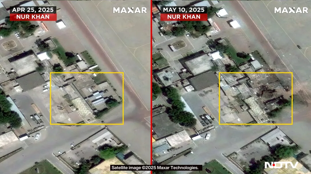
Nur Khan Air Base, strategically located between Rawalpindi and Islamabad, may have been targeted. Images show what are believed to be special-purpose military vehicles parked nearby. This base was also struck during the 1971 war.

At Rahim Yar Khan, a large crater was formed on the side of the runway following Indian strikes. This air base is located in the Punjab province of Pakistan.

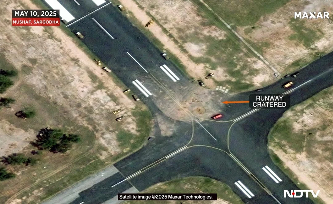
The Mushaf air base in Sargodha, a strategically important base of the Pakistan Air Force, sustained damage to its runway in two locations, with craters approximately eight meters wide.
The Significance of Independent Verification
The use of satellite imagery in verifying claims and assessing damage highlights the growing importance of independent sources of information in modern conflicts. As information warfare becomes increasingly prevalent, the ability to access and analyze reliable data becomes critical for understanding the true nature and impact of military operations. The role of companies like Kawa Space in providing this data is becoming increasingly vital.
What are your thoughts on the role of satellite imagery in modern conflict reporting? Do you believe it provides a more accurate picture than traditional news sources? Share your opinions and insights in the comments below.