Sinking Cities: NYC, Chicago, and 26 Others Face Silent Infrastructure Threat, Study Finds
A startling revelation has emerged from a new study, revealing that 28 of the most populous cities in the United States, including New York City and Chicago, are experiencing significant land subsidence. This slow but steady sinking, ranging from two to ten millimeters per year, silently compromises the structural integrity of essential infrastructure, posing a long-term threat that demands immediate attention.

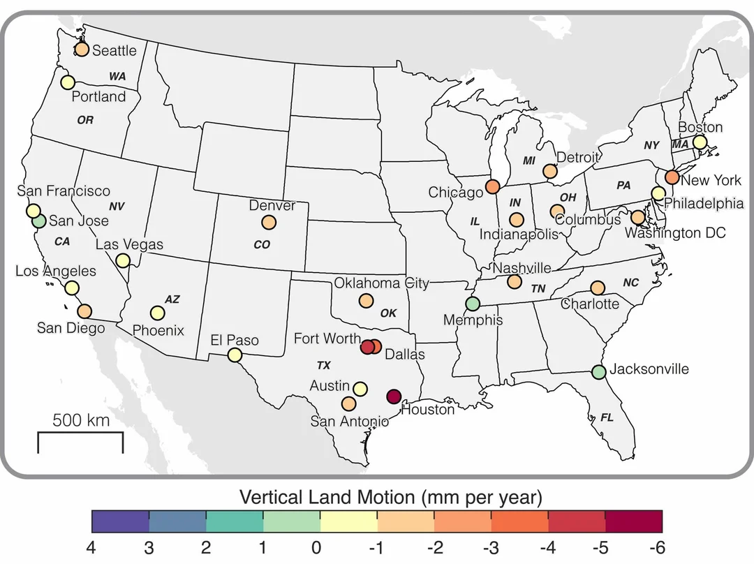
The study, conducted by researchers at Virginia Polytechnic Institute and State University, employed satellite-based radar measurements to create high-resolution maps of subsidence across major U.S. cities. The results are concerning: at least 20% of the land in each of the 28 cities is sinking, with 25 cities showing subsidence in over 65% of their area.
Houston, Texas, faces the most severe subsidence, with approximately 40% of the city sinking at more than 5 millimeters per year and 12% sinking at a rate exceeding 10 millimeters per year. This alarming trend is not limited to coastal areas; inland cities are also at risk, making them more prone to flooding and destabilizing buildings and infrastructure.
"Even slight downward shifts in land can significantly compromise the structural integrity of buildings, roads, bridges, and railways over time," stated Leonard Ohenhen, the study's lead author.
While natural geological processes contribute to subsidence, the study points to human activities as a major driver. Approximately 80% of urban subsidence in the U.S. is attributed to groundwater removal for human use. As cities continue to grow, this issue is likely to worsen, exacerbating the risks associated with climate change and sea-level rise.

A separate study highlighted the alarming rate of subsidence in the San Francisco Bay area, with some areas sinking more than 0.4 inches (10 millimeters) a year. When combined with sea level rise, this could lead to a doubling of projected water levels by 2050, posing an existential threat to critical infrastructure like San Francisco International Airport.
Manoochehr Shirzaei, associate professor at Virginia Tech's Earth Observation and Innovation Lab, emphasized the hidden nature of this threat: "The latent nature of this risk means that infrastructure can be silently compromised over time with damage only becoming evident when it is severe or potentially catastrophic."
Despite the daunting challenge, the study suggests that mitigating actions are possible. These include improved monitoring of subsidence, revised groundwater management policies, and proactive infrastructure resilience planning. Cities can also focus on areas with the greatest spatial variability, as these can experience the greatest hazard to infrastructure.
What does this mean for the future of our cities? The findings underscore the urgent need for proactive measures to address land subsidence and protect urban infrastructure. By understanding the causes and implementing effective mitigation strategies, cities can safeguard their future and ensure the safety and well-being of their residents.
What are your thoughts on this issue? Do you believe your city is adequately prepared for the challenges posed by land subsidence? Share your comments and concerns below.